Caz told me about the history of Burnbanks, a village built for workers building the reservoir, long since abandoned, but recently rebuilt as homes for sale. She also explained that the Lowthers, a name I had seen on several occasions and the river twisting below Rosgill, were a family of note in these parts - large scale landowners, whose name had been attached to various rivers, roads and villages. Allegedly a disreputable family, most of their fortunes had been squandered by their present day incarnation, and feuding following a death in the family was eating up the rest of the legacy. What a shame.
Crossing the ancient Naddle Bridge, we were into different country, the rocky Lakeland paths replaced by rolling green countryside. Caz’s house across the valley came into view, and crossing a soggy ploughed field and turning off the C2C to cross Rosgill Bridge, we arrived there shortly after. Some view.
Wednesday 11th July – Rosgill (0 miles)
The problem with bed and breakfasts is that rest days are rest days whether you want one or not. It was great to see Caz and her family, but I spent the day itching to move on, not least because it was the sunniest day we had had so far, with a lousy forecast to come. Still it afforded me the opportunity to learn about birds (Caz is a bird person, and she took me through the great tits, blue tits, chaffinches, green finches and a woodpecker who graced her bird table); to finish my book on the Spanish Inquisition; and to read Wainwright’s C2C book.
Thursday 12th July - Rosgill to Orton (10 miles)
It was good to be back in harness the next day, but whilst there was some sunshine at first, it soon clouded over. I didn’t agree with my guidebook’s hyperbole that few walkers would have walked between Shap and Kirkby Stephen “without acquiring a sense of the ancient, a passage through time, extending over two, three, four, maybe four thousand years into the dawning of man’s time in Northern Britain”. I must have been one of the “soulless, blinkered persons who passed by with little thought for our pre-history”. With hindsight, I would have done the next two sections in one day.
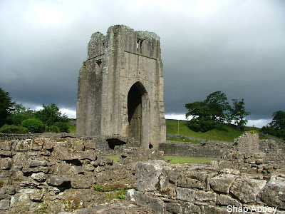
Crossing Rosgill Bridge, I disturbed two herons, which lumbered across the fields at my approach. Before Parish Crag Bridge, the sun coming out meant I removed my trousers legs, only for the clouds to have won the sky by the time I reached Shap Abbey. I dawdled there, enjoying the stillness, and wondering how Henry VIII had found it to dissolute it, buried in its fold of the River Lowther.

Moving on, the storm clouds gathered over the Lakes, drawing stark patterns over the landscape. A train passing by in front of me heralded my entrance into Shap – a non-event of a town since the M6 opening, its shops graced by historic photos of trucks holed up there in snow flurries pre-M6. Treating myself to a cup of tea and a bacon sandwich in the café was the limit of my Shap encounter.
Crossing the main West Coast line and the M6, and passing Oddendale Quarry, where a black quarry truck driver pleasantly waved at me, I was into what my guidebook referred to as limestone country. It was made up of a stone circle, some distance from the path and not easy to find; a large granite boulder on Crosby Ravensworth Fell; the detour up to the cross on Beacon Hill, with a view of the Howgills which would have been pleasant in better weather; and disused maltkilns above Orton. None of it enough to compensate for the rain.
Orton was a pleasant enough village, stone bridges, houses, a common in the centre of the village that had been left as a wetland. But again the rain stole its charm, and I was happy to reach the welcoming Barn House bed and breakfast, where I was greeted with tea and scones, and where I used a bird book to wrongly identify a bird I had seen during the day as a Great Grey Shrike - a bird usually only found in Canada.

Orton was also notable for its whitewashed church, where the cleaner told me that her daughter was getting married the next day and she was concerned by the impending weather – a concern I shared.
Friday 13th July - Orton to Kirkby Stephen (11 miles)
In the morning a delicious Barn House fruit mixture greeted me, but also grey and foreboding clouds. And the weather forecast was for worse later on. So I set out early, for the first mile along a road, and then past another nondescript stone circle, to a pleasant path across fields to the delicate bird haven of Sunbiggin Tarn, although no birds were there when I got there. At some point I passed the muscle bound critter shown below. It could be a Doncombe Akhenaten (but could equally be something else).

Skirting Sunbiggin Tarn, the rain started to fall heavily, and the next mile across Ravenstonedale Moor became a bleak trudge, where it was not always easy to see the onward path. But the rain stopped as the path snaked along above Bents Farm. As I paused above the farm, the Australian couple I had last seen on day one at Nannycatch Beck appeared, and I walked with them across the ancient prehistoric Severals settlement. Nothing to see there. My guidebook raved on about having a quiet chat with your conscience to stop you walking across it. A well trodden path showed that few people agreed. The path then twisted down to Smardale Bridge and we paused above the wooded Smardale valley punctuated by its elegant viaduct.

Our walk over Smardale Fell marked our transition into the Pennines, with the gradual appearance of Nine Standard Riggs pinpricking into the sky ahead. It was an opportunity for an unresolved discussion about the differences between fells, moors and hills, and for the Australian man to enthusiastically remark on the health of English Cows. Their waste product punctuated our walk through Greenriggs Farm, and then shortly after that we were entering Kirkby Stephen by a back road. I had a comfortable room in an upstairs room at the Black Bull Inn in the centre of the town, and it was fortunate I had arrived there early. The rain came down in the afternoon in impenetrable sheets. Would the weather be kinder for the crossing of the Pennines tomorrow?
The standards only loomed atmospherically out of the gloom a few yards in front of them. My guidebook said that no one knows why they’re there. Maybe their purpose was simply to be visible for miles around, which they had been the day before, but on a day like today, they would have just been a useful marker to help guide anyone stupid enough to walk this way from Kirkby Stephen to Keld in bad weather. My guidebook also remarked that the Rigg marked the Pennine watershed with water flowing either West or East from there. Today it didn’t seem like water was flowing anywhere. Somewhere in the whirlwind blowing all around me, I wondered how the standards had always remained there given that they are simply made of thin stones laid loosely on top of each other.

Some two months later, I came back to Nine Standards Rigg with Grumpus. The views from the Rigg were spectacular, right across to Cross Fell and to the Howgills. But today, as I paused at the Rigg, wondering whether I could sensibly remain there long enough to grant enough respect to the monument, two bright yellow tarpaulin coats appeared out of the gloom with Gwen and Chris striding along underneath them.
I couldn’t have hoped to have met anyone other than Gwen and Chris in this gloom. How rare to meet such generous people. Gwen, never fazed by anyone or anything, but always there, always supportive, always interested. Chris, always thinking through how to get the best out of people, with a bluff weather beaten sense of humour. The two of them together, working off and supporting each other, a pair of people uniquely brought together, self-sufficient, but open to anyone who deserved their generosity.
They immediately seemed friendly and so I asked them if they minded me walking along with them. I didn’t fancy picking a way across the Pennine bogs on my own in this weather. With Gwen and Chris this wasn’t the problem it might have been. Gwen in particular seemed to be particularly adept at charting a way through the mudpools. And shortly afterwards, as we descended below the cloudline, we caught up a large group of people, most of whom I was to meet up with at various points along the way. Firstly there was what we came to know as the United Nations party, in that they were a large guided party made up of people from all over the world. Then there was Richard, a youngish lad who was doing a long distance path for the first time, and had over-estimated his ability to carry a large pack, damaged his knee, and then had to get his luggage carried. And then there was Jennie and Tully from Seattle. Along with Gwen and Chris, they were to feature on many occasions of the onward walk.
At this time, it didn’t seem like I would know any of these people for long, because they set off before me, the belisha beacon coats of Gwen and Chris disappearing down the fellside. Following them, the path, marked by occasional jutting stonemen, meandered well trodden through bogs across the soggy expanse of North Yorkshire moorlands, now easy to see below the cloud level stretching across to Swaledale.

I caught up with all the people at a mountain hut half way down the descent, but they were just leaving, which was fortunate in that there wouldn’t have been room to shelter in the hut for lunch if they hadn’t moved on. Further down, the path aimlessly wandered over New Gill several times, a stream that was gradually growing, and with the abundant water at this time overflowing its banks at several points, requiring careful precision to not end up with a bootful of water. But then, as the sun finally decided to show its face, the path skirted round into the bottom of the more dale like scenary of Whitsun Dale at Ravenseat farmhouse.

Shortly after, I caught up with Gwen, Chris, Jennie and Tully, and walked with them down to Keld, and it was from this passage of sunshine walking down into the beautiful folds of the river Swale, that was to be with us over the next few days, that our friendship started. From my knowledge of previously walking the Pennine Way, I suggested that we take a slightly longer detour on the northern side of the Swale to visit Catrake Falls before entering Keld.
Catrake was as enchanting and welcoming as it had been the year before on the Pennine Way. Joining the Pennine Way at the farmhouse for the short stretch down to Catrake was like meeting an old friend, and after a brief stop at the falls, we climbed up to Keld. Keld is a tiny hamlet at the top of Swaledale that would be unknown to the outside world if it weren’t at the confluence of the Pennine Way and the C2C. Life would have been harsh and remote here once, but now Keld is a picture postcard village nestled into the folds of the dale, with attractively strewn stone cottages just about allowing the lonely road through. Competition is fierce for the few bedspaces available in Keld, and so I had booked my accommodation here first. In fact, I had particularly wanted to book into the famous Butt House, and had changed the date of my walk so that I could secure an overnight stay there.

Butt House is (or was) the home to Doreen and Ernest Whitehead. Doreen is famous for having written a book on bed and breakfasts on the C2C route, and is seen as being as much a part of C2C mythology as Wainwright. Whilst most people had said that staying at Butt House was a pleasant experience, Doreen also had a reputation as being a fearsome landlady, and so it was with some trepidation that we (Jennie and Tully were also booked into Butt House that night) approached the whitewashed building perched above Keld.
Doreen lived up to her reputation. If a typical north Yorkshire people exist, these were they. There was something of the League of Gentlemen about the Whiteheads – Doreen, the dominating personality that no one would dare refuse, least of all Ernest, scuttling around in the kitchen and dealing with the more mundane things.
But there was also a generosity of spirit that had earned Doreen her reputation as matriarch of the C2C and which seeped out occasionally from the craggy Yorkshire bluntness. And some sadness in that Doreen’s health was failing, making it difficult for her to move around. She had the look of someone who would stand up to anything, but advancing years were beginning to take their reckoning. And it also turned out that they had a son with terminal cancer. So they were planning to close the bed and breakfast and sell up in August. I felt honoured that I had managed to make my booking to join them for this one night.
Having checked in, and following a request to leave our muddy boots in the entrance hall which it would have been unwise to refuse, we were invited to join Doreen for afternoon tea. There followed a passage where time stood still, where Doreen, ensconced firmly in the doorway to prevent escape, regaled us with all things Yorkshire for perhaps an hour, whilst we nervously sipped tea and obediently ate giant slabs of delicious chocolate cake.
In this hour we briefly entered Doreen’s world – hearing tales of growing up in Keld. Was some of it a caricature of what Yorkshire people are supposed to be? Maybe so, but who cares? Maybe they invented the caricature. On asking about where they were intending to move to when they retired, Doreen bluntly stated that Ernest was born and bred in Swaledale, and he’s going to die in Swaledale – presumably meaning there would be few options available to them, particularly because she actually meant this little corner of Swaledale stretching from Keld around Kisdon Hill to Muker. They speak with a different accent further down Swaledale, and as for Wensleydale – a different language.
And if the photographs of Thatcher and Doreen meeting local MP William Hague made me slightly uncomfortable, the endless streams of invective against the current Government might have offended my socialist principles. On hearing about the supposedly ravaged health service, my meek defence of asking the Seattlers what it’s like to not have a national health service at all, seemed to go unnoticed, but the politics of the situation were not really important here.
She also made us a delicious evening meal, making us feel guilty because of her difficulties of getting around, and entertained us with further regalement after dinner. Later on, I found that another couple who were staying there that night had written a stinging story about Butt House on the internet, particularly unnecessary given that Doreen and Ernest were retiring in a month’s time. I wrote one back defending the Whiteheads. They were generous people who have worked hard over many years to make their guests comfortable and share them with a unique slice of life. Even if I didn’t agree with what she was saying, Doreen’s approach was a time honoured communication of life and values, and I respected that. Staying with Doreen and Ernest was a unique, colourful and memorable experience that brightened up my C2C trip. The C2C will miss them.
Sunday 15th July - Keld to Reeth (10 miles)
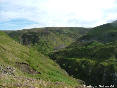
Decisions, decisions. Taking the path along the Swale – scenic and level? Or climbing Swinner Gill and going past all the old lead mine buildings – a sharp climb but stunning? Or a bit of both by dropping down to the Swale from Gunnerside? I opted for the Swinner Gill route – the old lead mine buildings sounded like something special and there was plenty of Swale walking later.

I departed Butt House in early morning sunshine past Catrake and the turn off to the Pennine Way. The path climbed gently up past the ruined Crackpot Hall, derelict since the 1950s due to subsidence caused by mining. Picture postcard views of Swaledale, with the Pennine Way path perched along the edge of Kisdon Hill across the valley. From there, I had remembered photographing the slash of Swinner Gill opposite, little anticipating that I would be walking up it a year later. If I had thought the path on Kisdon Hill precipitous, the path that edged into Swinner Gill was not a lot better! But the stark beauty of entering its cavernous mouth in the early morning sunshine distracted from the sharp drop.
Turning right over an arched stone bridge, built years ago to span Hind Hole Beck, the path started to climb up Swinner Gill. The old ramshackle and haphazard stone lead mine buildings stood sentinel to the chasm, silently inviting speculation as to the former working conditions. Not for their erstwhile occupants the meticulous ticking off of health and safety conditions I fear.
The path twisted steeply and languidly up the gill in the morning sunshine. Chris and Gwen appeared from below, catching up with me as I reached the top, from where views stretched over to Great Shunner Fell, another Pennine Way high point. Our meeting up was celebrated by seeing a frog cowering in the heather.

We walked on together over the moors at the top to the Lownathwaite lead mines overlooking Gunnerside Beck, pausing to reflect above the spectacular and painfully beautiful Bunton Hush scar splayed across the opposite side of the Gunnerside valley. On such a sunny day, it was difficult to appreciate the vast human machinations that had caused the blasted hillside.

As we sat reflecting, we were joined by Jennie, who was walking on her own. Last night at Butt House, Tully had scalded his foot in hot bath water. This was a serious injury, and they had had to call a doctor to treat his wound. Whilst he was now not able to take the more difficult route up Swinner Gill, he was not about to give up on the C2C, and he had taken the gentler route along the Swale.
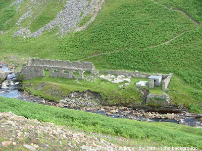
The path descended steeply down to the top of Gunnerside Beck, where we were joined by Bob and Sue at more old lead mine buildings, two more people who became part of our team over the next few days. At this time, I wanted more solitude to enjoy the Romanesque desolate ruins, and so watched them all move off up the path zigzagging up through the fern cover on the other side of the valley. Shortly after, I started to edge up the same path, creeping along the side of the valley towards Bunton Hush, views emerging down towards Gunnerside.
At this point it might have been a good idea to have taken the path down the beck to Gunnerside and the Swale. On a later occasion, Grumpus and I walked up the same valley from Gunnerside, not quite making it as far as the hush, but it was a beautiful walk, and would have been more welcome than the desolate moonscape that waited at the top of Bunton Hush.
The path onwards over Melbecks Moor was as nondescript as the path over Swinner Gill and into Gunnerside had been stunning. It was punctuated occasionally by more sentinel towers of smelting mills, but their restless charm was beginning to wear. Eventually the path drizzled down the Old Gang Beck to Surrender Bridge. It seemed that my body was beginning to surrender as I stumbled over the final few miles across moors, and then an assault course of numerous stiles over a chequer board of green fields into Reeth. I was happy to reach the Buck Hotel for a quick pint just as the rain started to fall. After sharing a cup of tea in a little café with Gwen, Chris and Jennie, I found the small but welcoming bed and breakfast run by Mrs Ann Bain in a quiet little side street off the main square in Reeth. I made it up to the Buck again for an evening meal. There was a lot of rain that evening, and I was hoping it would end by tomorrow. There had been no particular reason why I should have been so tired in the latter part of the day, but I slept well that night.
Monday 16th July – Reeth to Richmond (9 miles)
Happily it wasn’t raining in the morning. Meeting the United Nations Party for the last time as I left Reeth, I veered off the official route to avoid the road, on a winding path alongside the Swale to Grinton where a sturdy stone bridge spanned the river. Rejoining the road, I found a comfortable path heading across the fields, only to be waved at furiously by the United Nations guide telling me I was going the wrong way. I persevered and reached Marrick Priory without touching tarmac. The Priory was a non-event, but I met up with Bob and Sue there, who were chatty and friendly. Shortly after they left, Gwen and Chris appeared, but I was just leaving. The path climbed up the slippery and polished Nun’s Causeway through the damp and dark Steps Wood.

Throughout the day, the scenery gradually changed again from the bleak windswept nature of the Pennine fells to rolling green fields and agriculture, a prelude to what was to come on the Vale of Mowbray. Today’s walk was in and out of the attractive villages of Marrick and Marske, up and over stiles, several diagonal paths across fields, the replacement of former industry scars from the previous day with current farming industry activities, with the ever widening Swale in its green and fertile valley somewhere close by.
And then there were the people. Firstly I walked between Marrick and Marske with Richard, who I had previously met briefly coming down from Nine Standards Rigg, who told me about his struggles with his bad knee. Then Gwen, Chris, Bob and Sue caught me up again at Marske, and I walked with Gwen and Chris along the beautiful Applegarth scar, Gwen as ever carefully navigating our route, and Chris regaling us with countless charming facts about farming, cheerfully fitting in with the meandering nature of the day’s walk.
Having climbed up onto the scar, together we lazily watched the bustling industry of a farmer on horseback on the other side of the valley corralling his sheep across several fields, and then we looked out for Willance’s Leap. My guidebook referred to Willance’s Leap as part of the Applegarth scar where in 1606 someone called Robert Willance accidentally rode his horse over the 200 foot cliff, surviving himself, albeit losing a leg, but killing the horse. We weren’t quite sure which part was Willance’s Leap but somewhere around there I stopped to have lunch as the sun came out, overlooking a beautiful bend in the Swale, flanked to the side by Whitcliffe Wood.
Jennie and Tully (who had now healed enough to walk the path) passed me as I enjoyed my lunch. I received a text message from Alison, the Aussie Nurse I had last seen on Kidsty Pike, saying she had had to abandon the C2C at Richmond due to a family crisis. Emerging from Whitcliffe Wood onto the road leading into Richmond, I caught up with Jennie and Tully sitting on a bench by the road, their heads bobbling above the Welcome to Richmond sign. Richmond Castle announced its presence at the edge of the Vale of Mowbray, stretched across interminably to the Cleveland Hills, our destination in a couple of days.

Not being partial to road walking, I chose to avoid the mile long road trudge my map gave as the C2C’s Richmond approach, and found a path that slipped quietly down the hill to the Swale, albeit slightly doubling back at one point.

I was rewarded firstly by some beautiful hedgerow flowers, which I have been subsequently told by Grumpus are Himalayan Balsam and a “terrible pest”. The walk along the Swale was delightful. As it finally twisted on its final approach to Richmond, I had to pick my way carefully across slippery stone boulders between the river and the twisted tree roots of ancient woodlands. Richmond Castle, with its solid walls, perched over my triumphal entrance over the Swale Bridge. My overnight accommodation was just on the other side of the bridge.

The amiably eccentric Alan Bennett, the proprietor of the Restaurant on the Green, mistitled in that it was only a bed and breakfast and not a restaurant, told me that it had once been an old 16th Century Inn and brewery in the salubrious quarter of Richmond. Bob and Sue were also staying there. Having arrived early into Richmond, I climbed the steep streets up into the town, exploring the numerous little obscure alleyways and posting finished maps and books back home to lighten the weight of my pack. During my exploration, I bumped into Chris and Gwen who were similarly exploring, and recommended a visit to Swale Falls below the town.
By a circuitous route, choosing not to explore the castle due to its admittance fee, I edged down to the Falls, which were spectacular, reminding me for some reason of the falls in Jajce in Bosnia, which Grumpus and I had visited some three years earlier. We had approached Jajce from the North, having stayed the previous night in the Bosnian Serb town of Banja Luka, where either we had not understood Serb congeniality or they genuinely weren’t pleased to see us. Jajce had been the first town we had come to back in the Muslim part of Bosnia, and people were much friendlier. Whilst there had been evidence of the town being rebuilt, particularly its mosque in the centre of the town, it had not yet returned to its historic tourist potential. The Jajce falls had been a poignant and stark reminder of the war, with abandoned and derelict attractions for visitors alongside them, but still spectacular. The Swale Falls bore no resemblance to the Jajce Falls, other than that they were below the main town, but our trip to Jajce came into my mind as I whiled away a pleasant and reflective half hour there as the sun occasionally dappled along the surface of the Swale.
 Tuesday 17th July – Richmond to Danby Wiske (12 miles)
What to say about the 21 miles from Richmond to Ingleby Cross across the Vale of Mowbray, the painfully flat northern extension of the Vale of York? My guidebook did its best to convince me that “the low lying land, barley fields, quiet farms, and rural scenary of the vale are valuable diet balancing ingredients of the C2C feast, and should not be gobbled indecently”. Against that, many people on the C2C website recorded the Vale of Mowbray as dull, interminable and best done in one day. I’ll remain agnostic. It certainly wasn’t a high point. The first day was better than the second. But particularly in the sunshine that greeted both days, it had its moments of charm. Various encounters with members of our team probably also made it more enjoyable than it could have been.

Leaving Richmond I contrived to wander off the path twice, once carrying further on down the river, and once by the sewage farm. The path skirted high above the Swale on a muddy track through the Iron Banks wood, a beautiful interlude, and then headed across open country to Colburn Hall. After Colburn, the path headed into arable country, across two giant flat fields. I missed the path that turned to the left in the middle of them, which led me to some gymnastic crossings of hedges and barbed wire at St Giles. At the final approach to Catterick, I met up with Gwen and Chris having a break in the sunshine, and then walked on with them. They set a cracking pace, although it subsequently turned out that they thought it was me setting the pace, under the A1 thundering north, past Catterick race course, past the Catterick Bridge pub, over the bridge and along the Swale for the last time in hot sunshine.

As we left the Swale, we missed the path and walked along the road into Scorton – not a particularly pleasant detour. At Bolton on Swale, I paused in the churchyard, photographing the monument to Henry Jenkins, allegedly a man with a strong constitution who had died aged 169, having lived between 1500 & 1670, reputed to have swum in the Swale at the age of 100. He claimed to remember the battle of Flodden in 1512, the dissolution of the monasteries in 1536, and then is mentioned in court records in 1667. A pleasant enough tale.

The path from Bolton was a pleasant amble beside Bolton Beck, a verdant wetland area. I met up with Bob and Sue just as a heron blasted out of the undergrowth. I chose the field route for the rest of the way to Danby Wiske, which took me past Kiplin Hall and more farmland paths. A tale of two farms – Stanhow - a visitors book, carefully stored at the side of the path, inviting comments about the upkeep of the path; Moor House - the path diverted through a liquid manure field. The last two miles would have been pleasant - rough pasture, a wooded path, but a downpour was coming, and I picked up my pace.
I reached Danby Wiske as the lightning started to strike. Later, Tully told us how he and Jennie had taken appropriate precautions in the lightning – crouching down in the rain their walking poles in the ground at a distance from them – only to be passed by a farmer nonchalantly wondering what they were doing.
I had a pint in the White Swan, my ear bent by the person who tells every C2C walker about his Russian internet bride, probably because no one else will listen to him. I also paid a visit to the solid Danby Wiske church, where bell ringers practiced. Up close to the church, the sounds of the squeaking bell machinery added complex rhythms to the sounds of the bells, ever changing and intriguingly looping in and out of time as I walked back to the village.

The Old School House bed and breakfast, where Jennie, Tully, Bob and Sue were also staying, was run by the former White Swan landlord. Our full party, which now also included Lindsay and her son Simon, who beat me in a game of pool, collected at the pub for dinner. Perhaps having the four pints was a bit excessive, but it was a short day tomorrow.
Wednesday 18th July – Danby Wiske to Ingleby Cross (9 miles)
A short day and short of interest. Crossing over the main northern train line; a yellow bird flitting in the hedgerow alongside more interminable road walking; taking a detour across fields to escape the road to find the advertised path ploughed over; a quagmire section; encountering an overgrown River Wiske; coming across a strange sheep (and of course Chris knew its name); some charming calves – not much else to report from the day.
But after another seven miles of dull Mowbraying, I crossed the A19, not an easy task - the traffic was very heavy – and re-entered interesting walking at Ingleby Arncliffe, the prelude to the Cleveland Hills. I met up with Chris and Gwen again at the village’s ancient water tower, and then we removed to the Blue Boar Inn for a lunchtime pint, where we were joined by Bob and Sue and, despite a heavy deluge, we remained cowering under an ancient tree in the garden.
Park House, my overnight stop, where Bob, Sue, Jennie and Tully were also staying, was a short climb up into Arncliffe Woods. Climbing a hill again was most welcome. Park House was a beautiful overnight stop with dazzling views back over to the dales. Tully surprised our evening meal by telling us he had spent his young years in a Japanese prisoner of war camp.
Thursday 19th July – Ingleby Cross to Urra (13 miles)
This would be the last day that our team would be all together. I had opted for some longer days at the end and so from now on, I would be a day ahead. It was a bond built over six days and 70 miles that had been formed in an endurance moment on Nine Standards Rigg. It was to go out in style in warm sunshine on the stunning Cleveland Hills.

I felt fit and lively as I climbed through the ancient Arncliffe Woods. Low clouds clung to the dank woods, giving them a silent charm, and the radio masts at the top loomed out of the gloom. But the mist swirled and cleared as I headed out onto the moors, gradually opening up a view of crags and ridges ahead. A lot of quite enjoyable up and downs over the next few miles, in and out of a wood, and then up the steep Round Hill as the first test against India started. My notes record that I felt good at the top of the climb. Despite the up and down nature of the day, my body had responded well to the two weeks of walking so far.

The path then edged up Carlton Bank, past the abandoned gliding club, with the slopes beginning to come out with purple heather. Then a steep drop down to Lordstone’s Café, carved out of the rock in the valley, where Chris and Gwen were waiting. The rest of our team also arrived there shortly after, and we headed off up the steep climb to Cringle Moor, our last section on the route together, each taking our own pace to get there. At the top, we collared another walker to take a commemorative photograph, with the views across the chequerboard fields to industrial Teesside resplendent below.

Somewhere on Cringle Moor, Jennie took the photograph above of me reading a note that a C2C walker coming the other way had left under a rock on top of a small cairn. It advised ordering tea and scones at the Lion Inn at Blakey. By this time, the sun, which had been occasionally gracing the day previously, had come out big time, and walking along the jagged edge of the ridge, slashed by several valleys clawing into the North York Moors, was becoming a real treat.


Parting was such sweet sorrow. Not really, but as the team all disappeared off ahead of me, Chris and Gwen heading off through the ferns down Raisdale for their bed and breakfast, and Bob and Sue heading off north somewhere, it felt like a poignant moment. Only together over six days, but all those casual encounters and drifting conversations along the way had been colourful illustrations that had complemented the walking. It had felt like we were the C2C route as we passed through it, and everyone else circulated around us.

Another climb up Broughton Bank in beautiful sunshine brought me to the Wainstones, scattered rocks and crags strewn across the path. Up ahead I saw Jennie and Tully edge around their left hand side, above what appeared to be a sheer drop, and so I opted to take a path of sorts that struck straight through their middle. This involved some clambering, but a welcome interlude in the still heat of the afternoon.

Shortly afterwards, as I skirted White Hill before the final descent into the Urra valley, I caught up with Jennie enjoying the view over to the Cleveland ridge, and we made the sharp descent into the valley joining up with Tully at the bottom.
Was it the sunshine, the rolling and undulating crags along the Cleveland Hills, a feeling that the ten miles walked so far hadn’t been enough, or just a strange desire to make sure that no part of this exhilarating path was missed out? At this point, two bad decisions were made. I decided that I wanted to continue on along the path towards Round Hill, intending to take a path further on that descended down Urra Moor. Tully and Jennie decided that they’d join me.
So on we went. Unfortunate on two counts. Firstly, the scenery markedly changed. The rolling North York Moors, peppered by interesting crags and outcrops, changed into a featureless expanse – alright in itself, but it wasn’t the continuation I was looking for. Secondly, after a climb and a mile of walking along the moor, the path marked on the map heading down to Urra didn’t exist.
This led to us retracing our steps the best part of a mile, taking another path that traced the contour, before heading down an indistinct but attractive path that headed down through ferns to Urra, all of this now with Tully dragging some way behind with his bad foot. At several points, the path disappeared, and I was feeling increasingly concerned about whether the path would get through to our destination, albeit clear ahead of us, and guilty that I had dragged Tully on this excursion. Happily we did find our way through to Maltkiln House at about 7pm, to be told by the proprietors that the path we couldn’t find and the path below we had eventually taken had both been closed off due to the dangers of abandoned mine workings in the area. Hmmm.
Friday 20th July – Urra to Glaisdale (17 miles)
A challenge wanted and a challenge got. When booking the walk, I had remembered the twenty mile days I had done on the Pennine Way the year before and figured that by this point, I’d be wanting to strike out for longer distances. Unfortunately I hadn’t anticipated the bleak loneliness of the North York Moors, made starker by the loss of my companions of the previous days, and the cauldron of bubbling grey clouds overhead and the large amounts of road and stony track walking on this day.

Leaving at 7.30, the day started with a muddy climb through a wet forest back up to Urra Moor, and then a dull trudge up a long and featureless path over the moor. My guidebook referred to people getting lost on the moor and hence in 1711 a decision to install guide stones alongside the path, with one called the Handstone at the top of Round Hill. Behind it, a concrete trig point contrasted old and new markers. The path then splayed out across the moors, easy walking and I used it as an opportunity to gather some pace for the 17 mile day. The bleak moorland was interrupted by the Blowith Crossing, from where the Rosedale Ironstone Railway twisted its way along the top of Farndale valley.

The Rosedale railway had been built in 1861 to move iron ore, and had been abandoned in the 1920s. Initially conjuring up exciting images of trains lumbering along, the five mile stretch soon lost its charm, although its twist along the contours continued to allow fast walking. At the end of a long stretch leading to High Blakey Moor, I chiselled a greeting to my erstwhile companions in the sand on the path, although I subsequently heard that none of them saw it.
Finally, the path skirted High Blakey Moor, and the Lion Inn peaked out on the horizon, one final twist of abandoned railway away. It was still early, but I thought I’d heed the advice given on the previous day to have tea and scones at the Lion Inn. Its otherworldly charm was a welcome contrast to the bleak day outside (and the tea and scones went down a treat as well).
From Lion Inn began three miles of road walking that peppered the rest of the day, but I chose to take a short detour to see Ralph Cross at the head of Rosedale, which my guidebook told me had become a symbol of the North York Moors National Park Authority in 1974, so I felt I needed to pay my respects to it.
Eventually the path parted company with the road at Trough House, above the beautiful and heather strewn Great Fry Up Dale (I could find no explanation for the peculiar name) stretching down into Glaisdale.
At this highpoint, first views of the North Sea nestled on the horizon, but my enthusiasm to reach my final destination was mitigated by aching feet caused by the road walking. After a break at Trough House, I felt better, and enjoyed the twisting muddy path that snaked around the head of Great Fry Up Dale.
This wasn’t to last long enough, because the path rejoined another road shortly after, clinging to it and then another stony track over the next three miles down into Glaisdale. My feet hurt by the time I checked into the Arncliffe Arms in the Village, unfortunately sited as far from the centre of the village as it could be. My room was nothing special, but the food was excellent. I was pleased to have managed the extended distance, and now anticipated the final days C2C walk.
Saturday 21st July – Glaisdale to Robin Hood’s Bay (13 miles)

The final day dawned as overcast as most of the other days had been. There was a fine rain when I left, but this didn’t cause problems on the delightfully dank climb into East Arncliff Wood. Pillow stones and mud alternately guided me through the wood, until the path emerged back on to more road leading down to Egton Bridge. I opted for the sturdy road bridge across the River Esk, rather than the stepping stones further down, barely visible in the deluge, and then I paused briefly to look at the large Catholic Church, which my guide book told me had somehow been missed by the Reformation.

A pair of donkeys in the grounds of Egton Manor greeted me to the old toll path, dejected perhaps because of the don’t feed the donkeys sign. The old toll house announced 1948 prices, largely dependent on numbers of horses and wheels. It was good to see that hearses got a discount, but then maybe they should have been free. Would the sixpence have been passed on to the occupant’s estate?
The toll path twisted under the railway bridge, a bridge I was to come over in two days on the train going home, and then edged alongside the meandering Esk to join another road leading into Grosmont. Because it had started raining, I paused briefly at a café on the walk into Grosmont, before joining crowds of people enjoying the steam trains at Grosmont Station.
The climb out of Grosmont, the last major climb on the C2C, was long, savage, and all on a road, but my mind was taken off it by a tumble of Indian wickets. The views back to the North York Moors were stunning, and gradually emerging of Whitby, my final destination, to the north-east.
I welcomed the boggy path turning off the road, but not the busy A169 which I had to join briefly before descending to Littlebeck. I paused for lunch by the ford at Littlebeck, listening to Nicholas Parsons being interviewed in the cricket lunch break after India had been bowled out, and wryly observing the different approaches motorists took to driving through the ford – some just driving straight through, and some stopping and carefully assessing the ford’s depth – even with my helpful advice that they wouldn’t have a problem. Perhaps my wry observation made me look untrustworthy?
The Littlebeck valley is a delightful interlude before the end of the C2C. A muddy path that twists around tangled ancient woodland, firstly clinging to the waterfalls and rock pools of the bubbling Little Beck, and then heading up through the trees high above the stream until it reaches the spectacular Falling Foss. As I walked through this stretch of paradise, the sun came out, amplifying the splendour.
In the midst of the valley, someone called George Chubb had carved out a rock and had called it the Hermitage. No one is quite sure why, but the view out of it over the wooded valley would certainly have been fit for contemplation.
I felt I needed to take the short detour along the precipitous path to Falling Foss, which proved to be spectacular, and then I sat for a while in contemplation by the beck, liberally assaulted by midges.
I had decided I was going to head straight across land to Robin Hoods Bay, rather than take the official route through Hawkser. The road walking on the official route held little attraction, and I figured that I was planning to walk up the coast the next day, so I didn’t need the coastal approach to the town. And of course, I wasn’t keen on the additional three miles or so.

So, emerging into the sunshine, I jutted off up the fern covered slope at the end of the Littlebeck valley onto an indistinct path that meandered over the boggy and misleading Low Moor. Whilst the destination was never in doubt, announced by the busy A171 on the other side of the moor, in the end, the only way to track across this impenetrable barrier was to follow one of the many gullies criss crossing the moor. Crossing the main road, this led to a long stretch next to farmland, and finally to an overgrown path that had not been walked for years, from where I got my first views of the red roofs of Robin Hoods Bay below.
I still had to negotiate a steep and twisting road, a field full of aggressive cows (which required some equally aggressive stick waving to fend them off), a very muddy stretch into Fylingthorpe, and then the caravan site from hell to welcome me into Robin Hoods Bay. Discovering that my bed and breakfast was at the high point of the town, I relaxed into a couple of pints at the Bay Hotel with an Australian couple who had also just completed, and signed the hotel’s C2C book.
 Sunday 22nd July – Robin Hood’s Bay to Whitby (6 miles)
Did this end section work? Intended as a triumphal epilogue to get to the train station in Whitby, I’m not sure that it was actually anything that special. And I don’t really like cliff walking! But first there was the ceremonial boot wetting, and the placing of the stone I had carried from Irish to North Sea, both of which I did in the early morning sunshine by the Bay Hotel, enjoying the town’s narrow alleyways and side roads whilst there were very few people around. It all seemed a long time and a different world since I had stood in the Irish Sea.

Leaving Robin Hoods Bay, I did come to appreciate the benefits of approaching the town from the coastal path. The view back to the town was inviting, strewn narrowly across the strip of land leading down to the sea. I was joined by a large guided group just starting out on the C2C going from east to west. It felt like I was an old pro now!
After I parted from this group as they turned inland to Hawkser, the walk to Whitby was largely uneventful. Many vertiginous cliffs, including one section where I had to climb over barbed wire to walk along a field. A lighthouse. Islands of jet appearing like submarines from the North Sea. A sprawling caravan park. Whitby Abbey looming out over the fields. All good stuff, but in my heart I had already finished.

The crowds at Whitby were not welcome. But, it being Sunday, finding a place to have a Sunday roast was. And then because I had to wait for my train, I found a pub to watch the dying embers of the test match – the final result leaving England 343 runs ahead, but with not enough time to bowl India out a second time. A shame because England went on to lose the series.
As my train pulled out of the ramshackle palm tree lined Whitby station, snaked its way through the beautiful Esk Valley (of course now in gorgeous sunshine), and then under the North York Moors, I had a chance to reminisce. There had been dazzling highpoints on the walk – the cliffs at St Bees; walking the Lakes with Grumpus; meeting up with Caz on Kidsty Pike; extreme weather on Nine Standards Rigg; Keld, Doreen Whitehouse, and the folds of Swaledale; the post industrial spectacle of Gunnersbury; the Swale Falls at Richmond; the North York Moor edge; and Littlebeck Valley. And above all, the bond that had formed between our party from Nine Standards Rigg to Urra – a journey into friendship that ran alongside the path.
But was it the lack of sunshine? Was it the short days, almost necessitated by the design of the walk? Was it the shorter overall distance? Was it the greater number of people encountered along the way? Was it the lack of bleak moorland sections? Were there just too many attractions? Or was it just that nothing could have competed with the Pennine Way? Somehow overall, as I sped back to Birmingham, trying to spot where the train zipped past Danby Wiske, I knew that the C2C had not been the challenge and life altering experience that the Pennine Way had been. But it had been a light hearted, relaxing and friendly holiday nonetheless.


